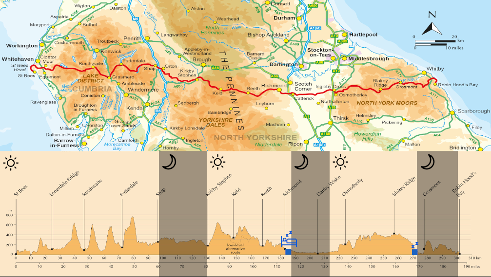
190 MILES ON FOOT (SELF-SUPPORTED) IN UNDER 3 DAYS
Wainwright’s Coast to Coast is one of the most popular walking routes in the UK, and soon to be given National Trail status. The 190 miles crosses over three National Parks: The Lake District, Yorkshire Dales and North York Moors. The first time I had crossed the C2C was with my brother, in 2008. We’d hiked and camped it over two weeks. I absolutely loved the route, and in 2013 I decided to test myself with a 4-day crossing. I ran during the day, and took various forms of accommodation each night. I also did a run/walk in 2014, running/walking through most of the first night, which was also a great experience.
I first had the idea to make another crossing of the C2C in April, as I was keen to find myself a decent challenge during the summer. Obviously, I’m a fair bit older and not as fit as I used to be. I also do a lot less running. But I still keep quite active with running, and racing on Zwift. So, with good preparation I felt a 3.5day crossing of mainly walking and limited rest would be a big challenge while still allowing me to enjoy the route and share the final night’s walk with my brother. I later rounded that down to 3days.
With just a few weeks to go I found out that as long as I completed the C2C in under 3days 4hrs I could set a self-supported record also known as an FKT (Fastest Known Time). In order to get that record I had to adhere to various rules. One of which was that I couldn’t have anyone walking with me or even “spectating”. This was a shame but my brother agreed that it seemed a good opportunity not to miss so would instead meet me at the finish but be available should I have to drop out.
I chose the 1st of August because this was around a full moon, which will aid with navigation on a clear night. A 6am start meant I could hopefully get a decent nights’ sleep and make the most of the daylight while fresh. Unfortunately, I didn’t realise July was going to be one of the wettest on record!
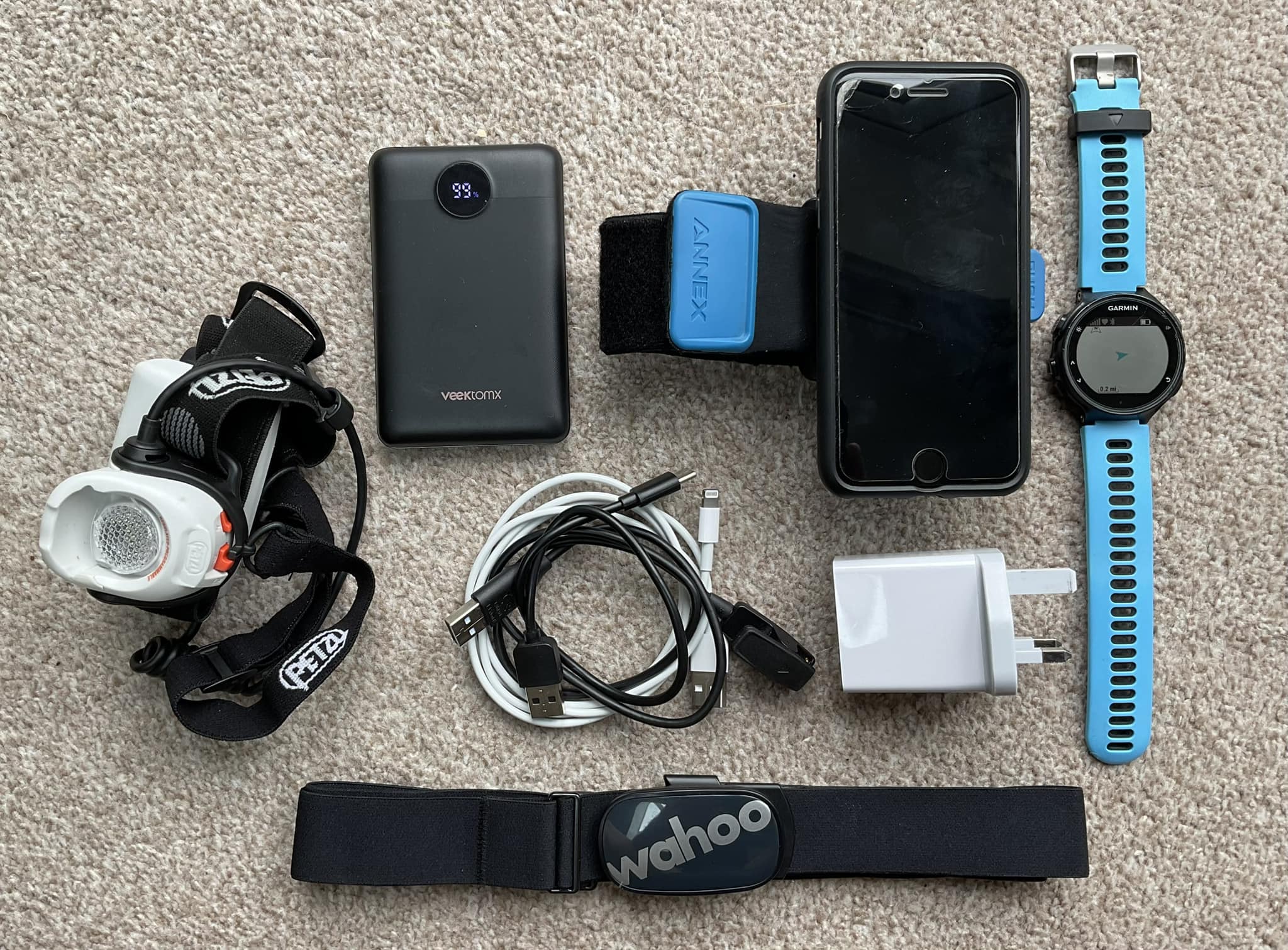
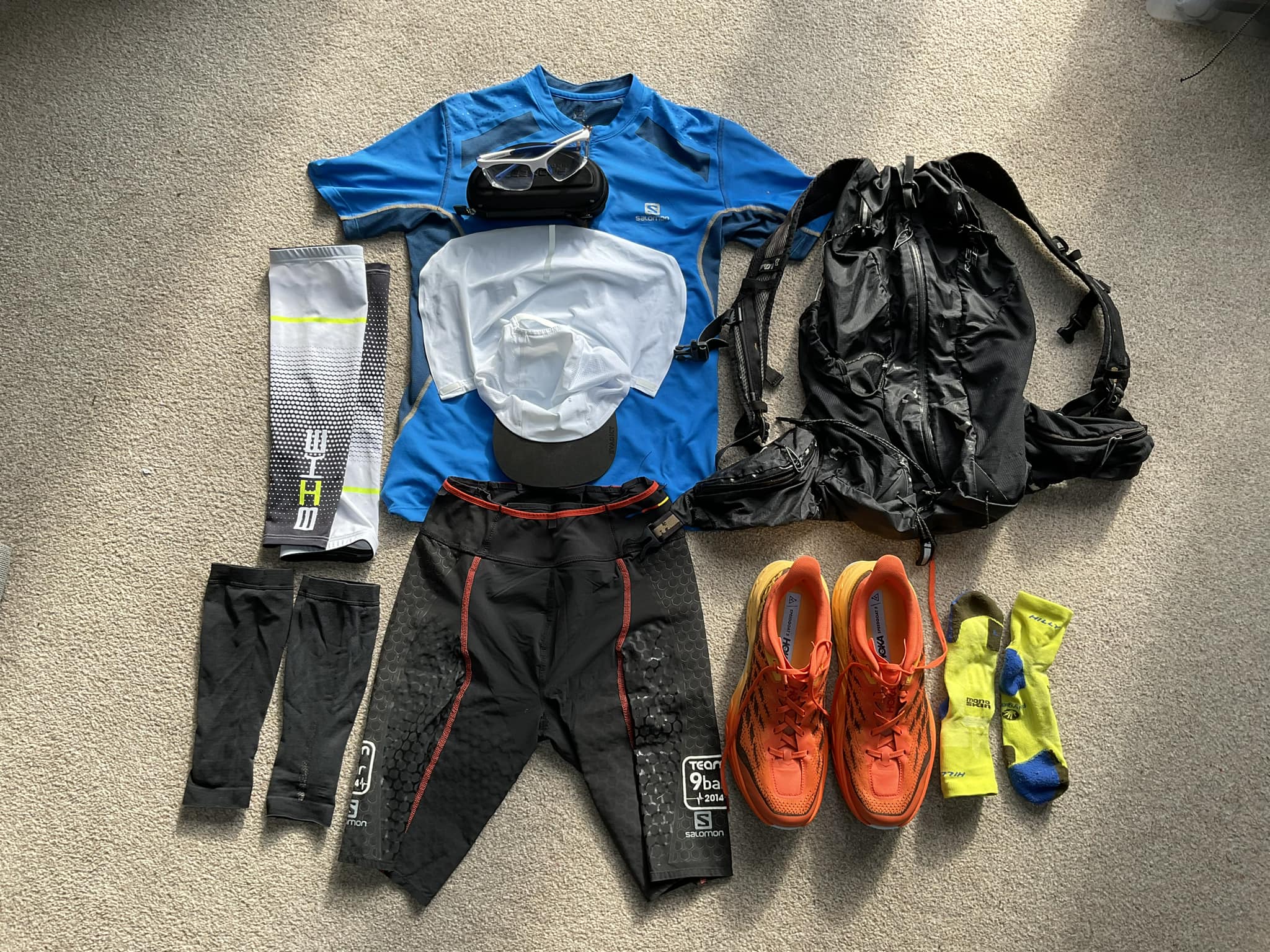
My preparation over the preceding weeks was thorough enough. I’d created an itinerary I thought would be doable and started to get together some old gear, as well as buying a few new items. The shoes and backpack were the most important. I finally settled on buying some Hoka Speedgoats, but I decided to keep my old Inov Elite backpack (25ltr). The shoes felt quite cumbersome but I knew the extra padding would be appreciated on the second and third days. The backpack sits very well around the back, but only has a couple of available waist strap pockets. I couldn’t reach around for the 1ltr filter bottle so improvised by using an Inov8 waistpack with a 500ml soft bottle inside. This would be topped up from the 1ltr bottle during the walks and rest periods. I had plenty of time to work on the backpack weight, finally getting it down to 3.5kg (without food and liquid).
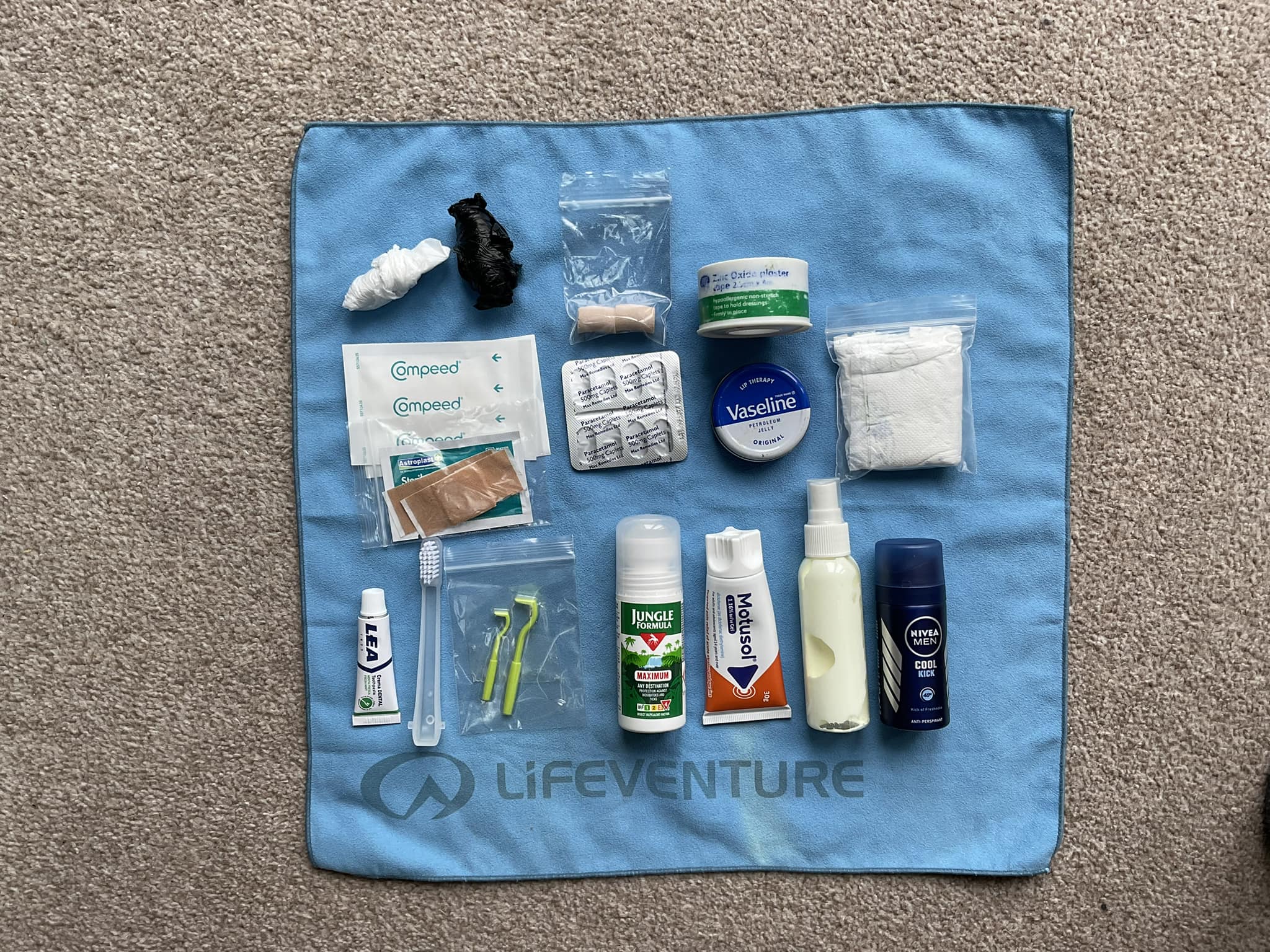
I’d not done a lot of training. There wasn’t enough time to build a solid base of running. But I’d done some log walks and a few long runs and bike sessions. Unfortunately, I’d picked up a couple of colds during those three months, the last one just a week before the attempt. Bodyweight was 67.5kg for the start.
Monday 31 July
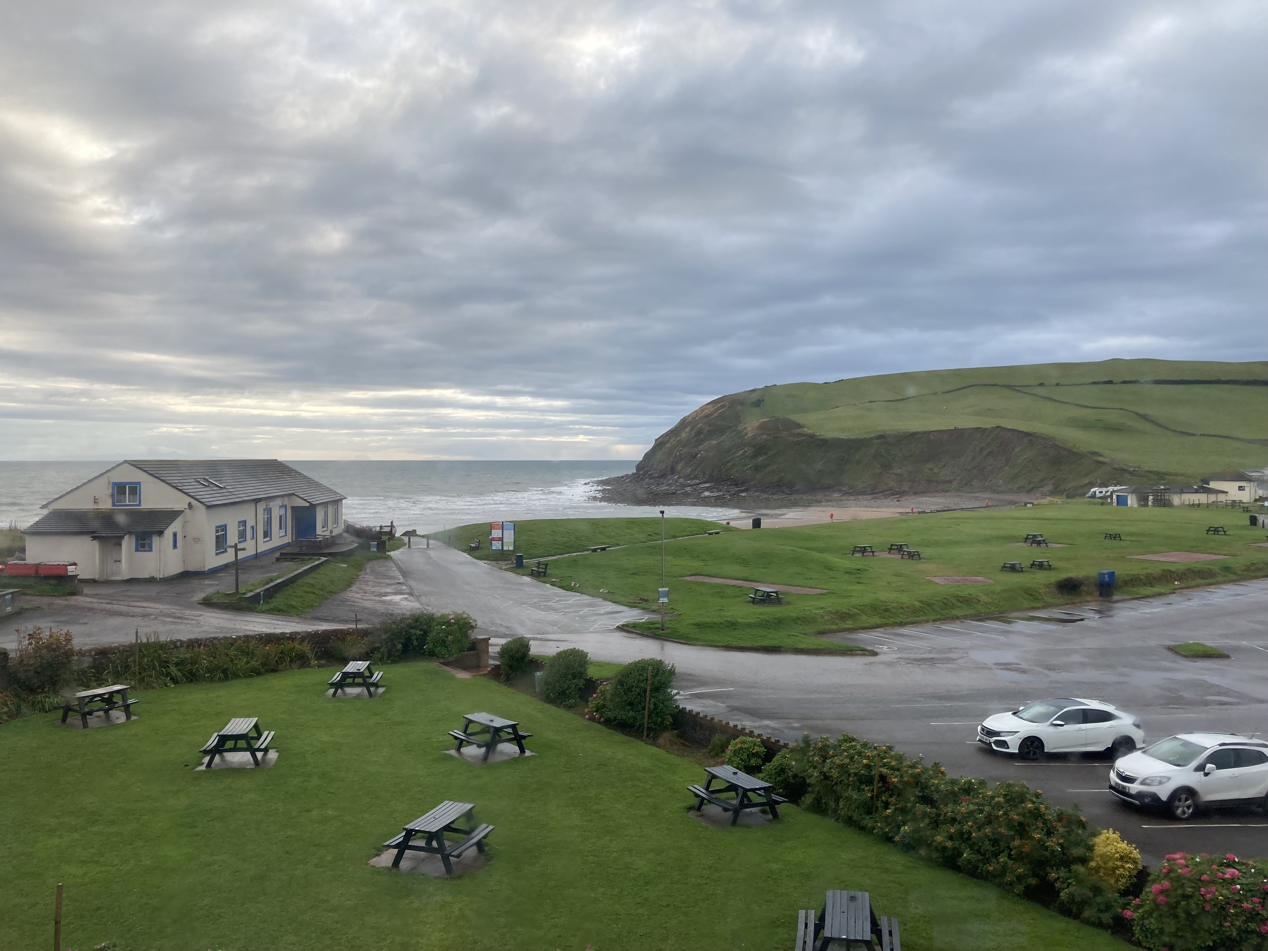
We drove up to St Bees during Monday afternoon. The weather was not great, overcast and light rain all the way up. But I still felt confident and in good spirits, keen to get started! It was pretty cold and windy at St Bees and we couldn’t book in to eat anywhere. Luckily my brother had plenty of savoury food to eat so I started to wind down for the evening. Great view of the beach from the Hotel, but the wind was pretty strong against the window all night. Normally I’d find this quite therapeutic, but it became a reminder to me of what lay in wait in a few hours’ time so I didn’t get much sleep.

Tuesday 1 August
St Bees – Cleator (9miles covered, arrived 7:30am)
Waking up to the sound of the wind and rain I decided to get a head start on breakfast, and down a collection of snacks with chocolate porridge(!). My brother came in to wish me luck before I headed off to the start point, keen to get going. I started at 5:50am. Felt pretty good for the first few miles, but I already realised it was going to be hard to keep to the scheduled pace on the itinerary. I had an average pace and ETA set for each of 25 sections along the C2C, the first being at Cleator. I’d based the pace on my previous run/walks over the C2C and the other supported and unsupported records I’d sourced. Because the wind blew from the west, I was finding it a little harder at times to keep my balance on the tight coast path. But after four miles the route turned inland, heading east, and despite the drizzle I could get a small benefit.
I’d decided to navigate with Harveys maps, either in-hand or in a waterproof case hanging from my neck. At the same time, I followed/tracked a route pre-loaded to my Garmin watch. The gpx of this was Damian Hall’s supported record, on the FKT website. Although this all seemed a good practical idea in advance, the tracking wasn’t necessarily accurate enough (and became my undoing later). Whether it was the gpx I loaded or my watch, the lines I tried to follow were straight and stretched. So, I had to anticipate turns using my Harveys map and previous knowledge of the course. It meant several stops to consider my options and double check the map, as I couldn’t afford to take any wrong turns. Generally, I did OK and didn’t go off course, but I did waste time checking.
Because of the various little stops and pauses I struggled to keep to the pace. I had intended it to be a balance of running and walking on the first day but it felt more like I was running and pushed to reach each destination on time. I reached Cleator on schedule, but it had been harder than I imagined it would be.
Cleator – Ennerdale Bridge (14 miles, 9am)
Leaving Cleator I had to head up my first climb, Dent Hill (340m). I always forget how sharp this climb can be, but I felt pretty good going over the top. The descent was both steep and a little overgrown and wet. But the shoes were doing a great job of gripping and keeping the feet dry and warm. I would have preferred to walk steep descents as running these can take a lot out of my quads as well as increase chance of damaging toe nails, particularly starting with shoes one size too big (to cover the swelling later). Still, it was fun and exhilarating bombing through the undergrowth on the downhills.
Ennerdale Bridge – Honister Slate Mine (27 miles, 12pm)
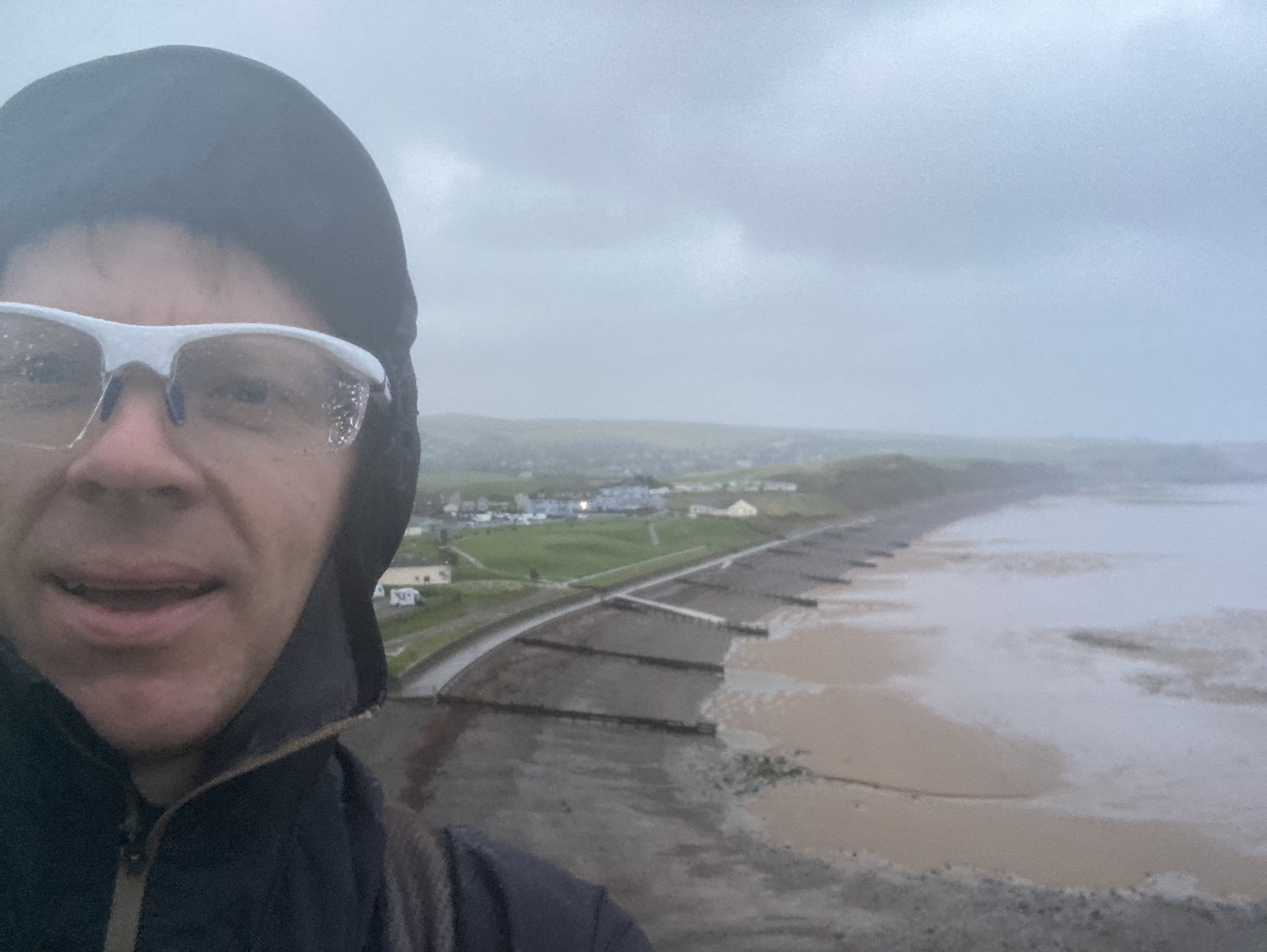
I’d left a cache of a bottle of water and a small bottle filled with energy gels (500cals) just before Ennerdale Bridge. I was only 5mins behind schedule and knew I had a nice flat stretch along the road to Ennerdale Water, where I could open the legs up and make up that time. Ennerdale Water was a beautiful sight, even under heavy cloud. The first few miles were comfortable and I got to pass and share a few words with some hikers. But after two miles the trail started to get more technical, with some scrambling, rocky sections and streams passing over them. It was along this section that I finally got my feet (properly) wet. I realised that trying to avoid the water just wasted time as my feet would inevitably get wet at some point anyway. So for the rest of the day I became increasingly disregarding of the streams that flowed over the paths and just waded or ran straight through, sometimes to the amusement of walkers who were trying to negotiate their way over rocks to keep their feet dry.


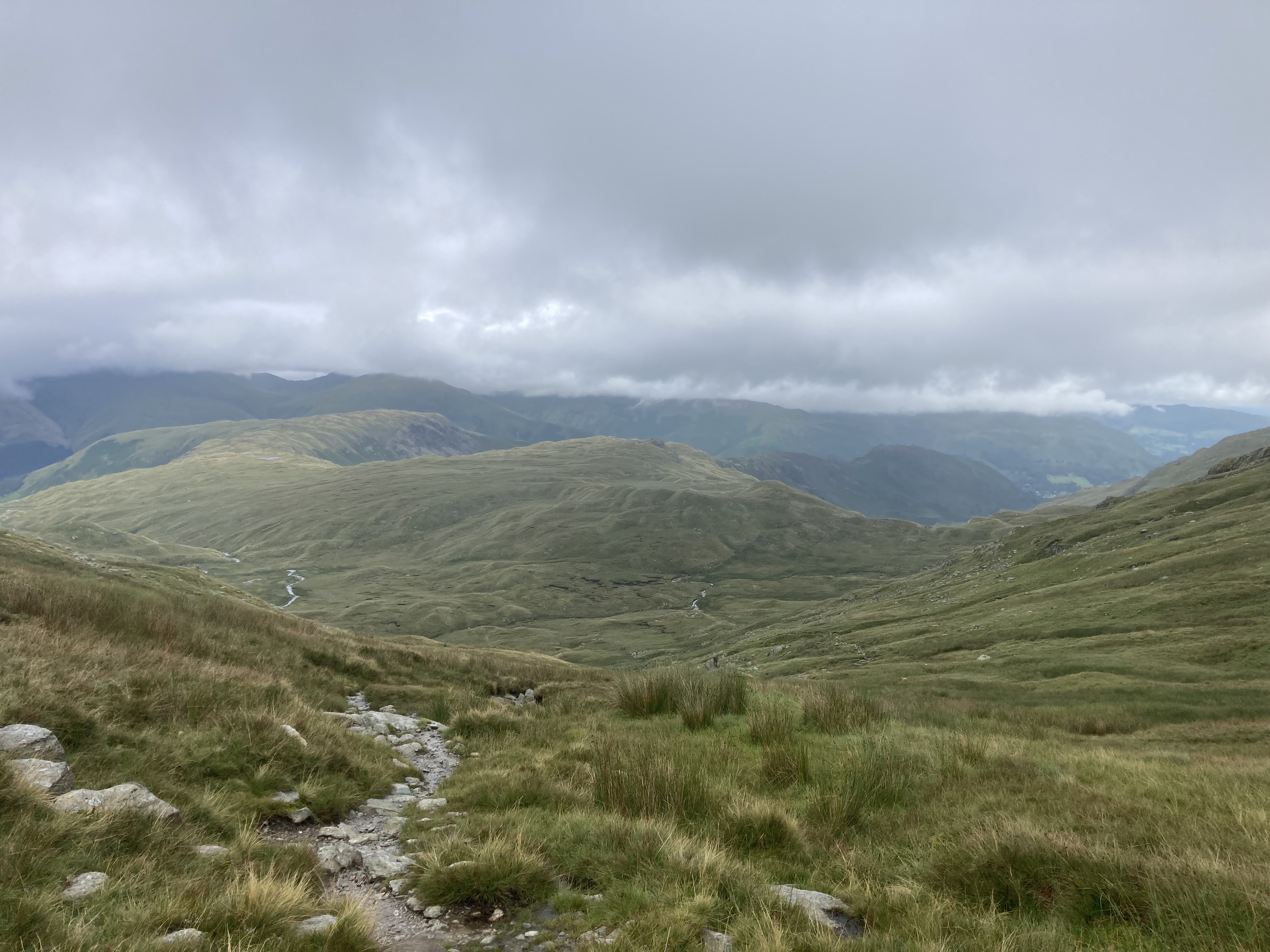
The track that follows from the eastern end of Ennerdale Water to Black Sail Hut Youth Hostel is where I realised I could no longer keep to continuous running. I was already starting to flag and having to increase the time spent walking. I took a 10 minute break at the Youth Hostel, and then heading back out to some marshy ground leading into the climb up Loft Beck, and Grey Knottts (600m), then back down to the Café at Honister Slate Mine.
Honister – Grasmere (40 miles, 4:30pm)
This was my first proper break. I was 30 minutes behind schedule at this point so reduced my break here from 45 to 30 minutes, which actually still felt like a decent break. I had a coffee and a cornish pasty, and packed away a sausage butty for later. Topped up with water at the Youth Hostel further down the road in Rosthwaite and had a cake. The person serving me was very friendly and we got into conversation, before I realised I was on the clock!

From Rosthwaite you have a long flat then gradual climb towards Lining Crag. I was very wet at this point but still in good spirits. I could turn out a decent walking pace with a few minutes of running here and there, and despite the crossing streams I was still within 30 minutes of my schedule. After scrambling up Lining Crag and Flour Gill to 550m I made a costly navigational error. I was sweaty and damp at this point and it was quite cold in the mist, so I was keen to get moving into the next valley. Rather than look I followed the tracker on my watch. There were two route alternatives laid down by Wainwright here. The easier, conventional one heads straight down Far Easedale Gill into Grasmere. I’d done this on all three previous occasions and knew I could run and make some time up here. The harder alternative takes a high route across three summits, culminating at Helm Crag. This is the route the watch sent me! I’m still surprised Damian Hall set his record taking this alternative route.


I had to laugh and admire the views, before another quad busting descent and a few small navigational errors to double back on the route. This not only wrecked my legs but meant I was now 1hr40min behind schedule. I was in such a mental fuzz and annoyed with myself at this point, that I missed the Youth Hostel, where I planned to stock up on more carbs.
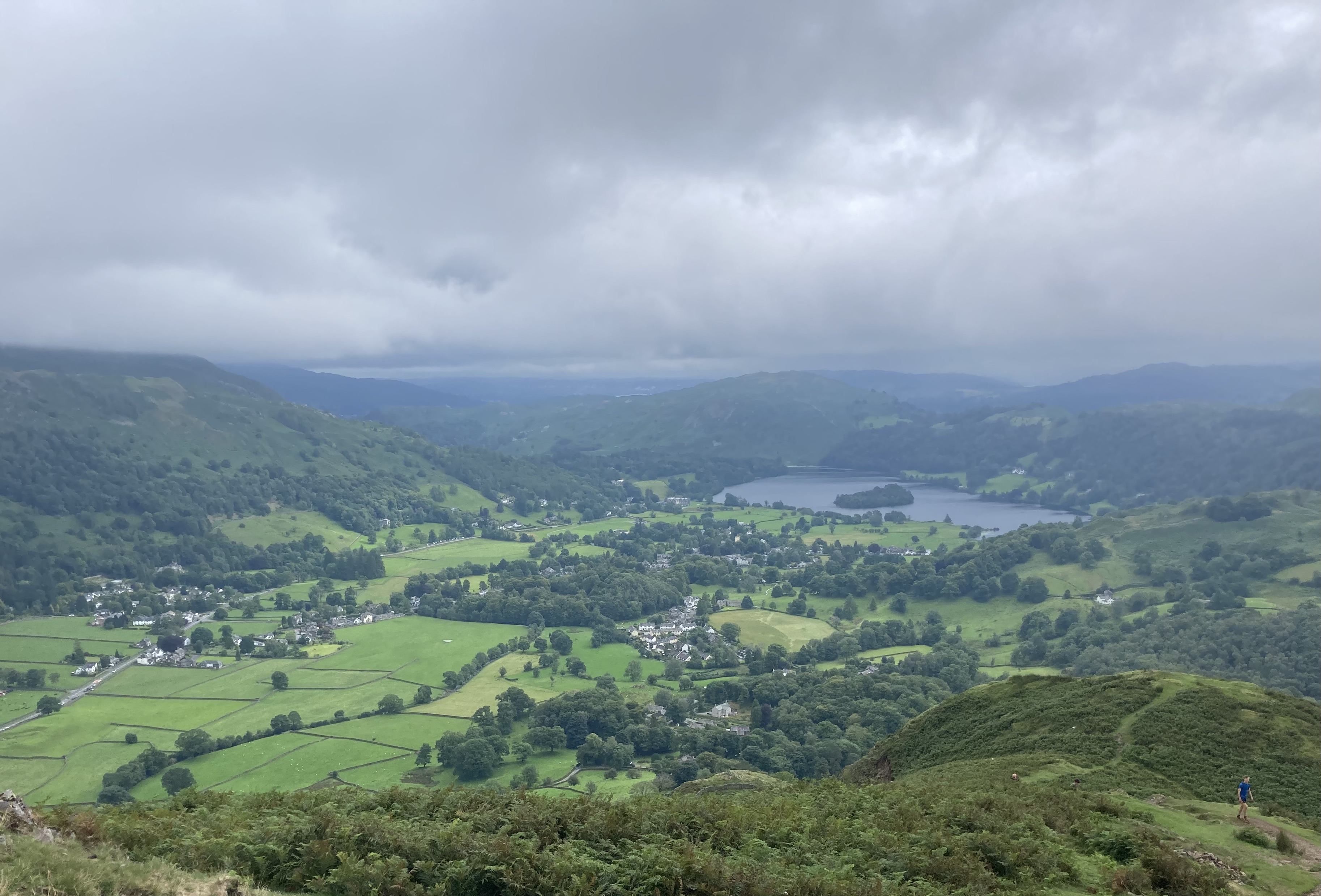
Grasmere – Patterdale (48 miles, 7:30pm)
Despite the drop in my spirits I kept walking, hoping I could snap out of it. The legs were already fatigued a lot earlier than they should have been fighting various issues to keep to the schedule, and my energy levels were running low. I decided to take a break on the climb out of Patterdale, a change into the last of my dry clothing, hydrate and eat the sausage butty. Sometimes a time-out like this can reboot and lift the mood. Grisedale Tarn was enshrouded in mist but the views coming down Grisedale towards Patterdale were awesome.
Luckily my brother was only a one-hour drive away so I was able to phone him and give him the heads up that I would have to stop at Patterdale. Of course, I thought about pushing on but the next section was the hardest. A climb to the highest point of the C2C at Kidsty Pike (780m), followed by a technical descent and then following the side of Haweswater. I was wet, cold, with no warm fleece or jacket, smashed quads and very hungry. I had a cache of some more warm clothes near Orton, but that was at least 8hr further on. The safety switch clicked on and I decided the safest option was to bail out. To this day I still think that was the right choice.
Disappointed I couldn’t complete the whole thing but I knew it would be a tough ask, even without the issues. Everything needs to go your way. I’d enjoyed the planning of it. It gives you something fresh to focus on, and build up the fitness. Would I try it again? I’m keen. But time is running out to have the right conditions, fitness and window to slot it in this year. Perhaps next year, if there’s a nice dry period.
A great experience though. It very much felt like a battle against the Lakes, and that’s what I’ll take from it, as well as the amazing views. The body took a beating but just came away with the one black toe nail (no blisters) and friction from the waist pack. I was back training the following week.
Thanks to the Active Foot Company (Worcester), for supplying the perfect shoes and socks for the job, my brother Dean, and all the information and advice from Alby and co on the Coast to Coast Facebook group.
